 Photo: Waterside Inn, Mountsorrel - David P Howard
Distance: 5.4 miles (8.7km)
Time to complete: 1.5hrs
Difficulty: Easy/Moderate in higher water
Portages: 4
Weirs: 2 (3) with options to portage
Gauge readings: 2142 (0.7 - 1.8m>)
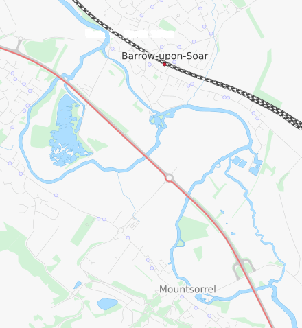
Start: The Mooringings, Barrow upon Soar
Map reference: SK573174
Post Code: LE12 8PN
Alternative starts:
Barrow Boating, Barrow upon Soar
Map reference: SK577168
Post Code: LE12 8LH
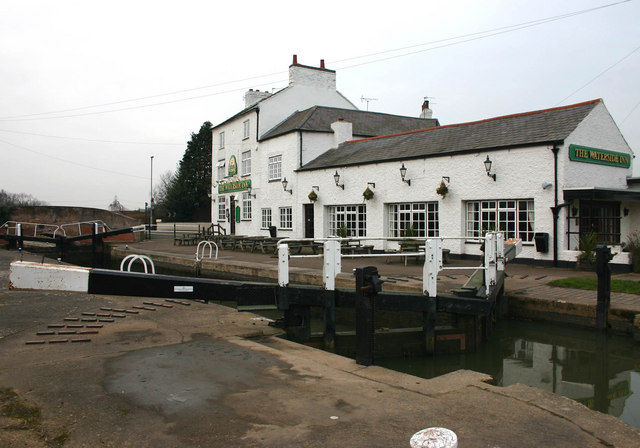
Waterside Inn, Mountsorrel
Map reference: SK582152
Post Code: LE12 7BB
 Link to route in PaddlePoints
 Soar Tour 2015 on Mountsorrel backwate
A figure of eight paddle that includes the Barrow Loop and a loop around Mountsorrel. Start at the Moorings Pub. Parking is available but please contact the pub, preferably in advance of your visit or on arrival. Toilets available. Alternative start points are Barrow Boating who also hire boats although parking is tight or on local streets or The Waterside Inn at Mountsorrel. Wherever you choose to start, please find time for a drink or meal in return for their hospitality.
Starting from The Moorings, head under the road bridge (which has a grade II historic listing) and turn left into the cut. After 100m a portage from the left bank is required. It runs over a service road to Proctor’s Pleasure Park and around the lock re-launching onto the canal on the right hand side above the lock. Continue along the canal for 600m until you reach Mill Lane Bridge.
On the left bank is The Navigation Pub and on the right bank is Barrow Boating. This is an alternative start point. Both the pub and seasonal café at Barrow Boating have toilet facilities. 200m beyond the bridge the canal cut ends at Barrow New Weir on the right. Continue on the river, now against the flow paddling upstream. A row of houses with large riverside gardens on the left keeps the interest. A right hand bend in the river starts the transition from one side of the flood plan to the other. On the left hand bank is a marina and caravan park followed soon by the backwater rejoining the main flow.
At this point you have the choice about which way to complete the Mountsorrel loop. Continuing on the wider channel against the flow is generally easier going under the A6 bridge and approaching the village under the grade II listed ‘1860’ conveyor bridge, the 90ft span is considered one of the finest brick-built single span bridges in the country more info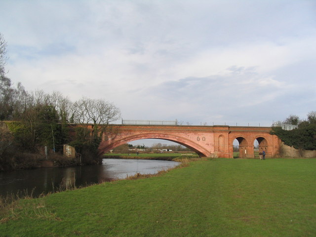 Photo: Mountsorrel convayor bridge - Tim Heaton .
To the right is the ‘W’ weir, which it is hoped, will be modified to allow passage both up and down (using a canoe shoot). Until then it is an awkward portage over the road by the lock. Be very careful of traffic as you cross. If possible station lookouts either side of the bend and bridge. Re-launch above the lock by the Waterside Inn; you may even decide to stop for a coffee or drink. To the right (river left) a channel goes off to the top of Mountsorrel Weir. If you are doing the loop in the opposite direction or you just fancy it, the weir can be shot down the right hand ‘V’ of the ‘W’. As always, inspect and check before shooting.
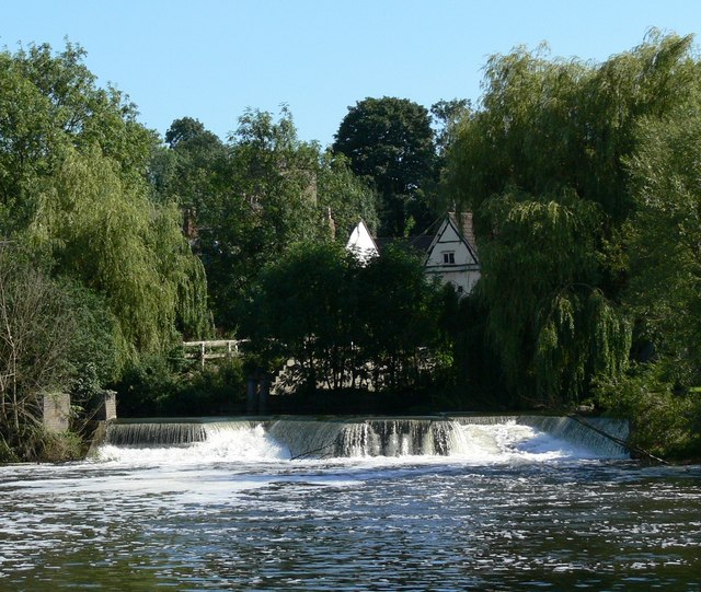
Continuing upstream, away from Mountsorrel, pass under another of the A6 deck bridges. The weir that drops down onto the backwater is on a tight right hand bend. It is possible to fit a canoe between the wall and Armco barrier at the end furthest from Mountsorrel. It is best to hold the barrier as you work yourself and your boat towards the centre footbridge support and turn and shoot down the gentle steps from there. In high water some of the bridges on the backwater become difficult or impassable. Think again about continuing this way if the weir steps are under the flow of water. Retracing your steps may be necessary.
 Mountsorrel backwater weir & footbridge Dave Bevis
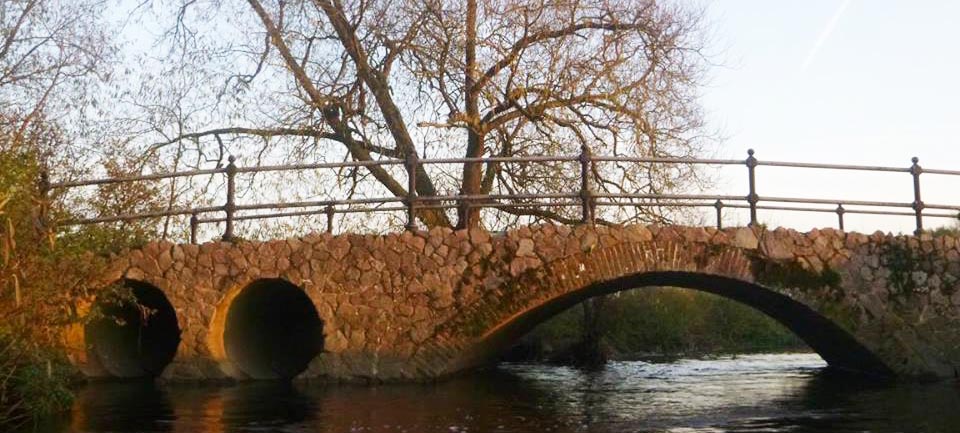
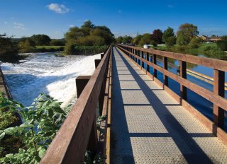
The backwater winds its way under the Sileby Road Bridge then a bridal way bridge shown in the photo at the top of this page. This is followed by the conveyor belt continuing towards Barrow on a rickety bridge. This is an interesting narrow and somewhat overgrown backwater with lots of wildlife to spot. The last bridge is a very low carrying a footpath through the marina. At normal flows it is just possible to get underneath in higher flows be ready to beach and carry over. This excitement is just short of your return to the main river. Turn right and retrace your stokes to Barrow Weir this time with the flow.
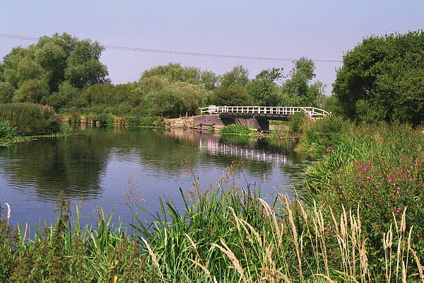
 Footbridge over Barrow New Weir
The portage point is on the downstream end of the weir and is clearly marked. The weir barrier has an open section towards the middle to allow for paddlers to shoot the weir. An inspection can be made from the footbridge running over the top of the weir. Care should be taken to check the clearance under this in high waters. If you are unsure, use the portage point and re-launch from the small beach below the weir. This next section is on the natural course of the River Soar as it twists and turns towards Quorn. After a sharp right hand bend there is a large reed bed with a clear ‘S’ shaped channel leading to a metal footbridge. In very high water the clearance on this bridge can be very restrictive. An inspection from the left bank of the right hand bend in such conditions will inform the need to portage or, as has been the case, paddle in the field! Below the footbridge is one of the A6 road bridges and a more open flood plain. Power lines cross and lead to Mountsorral quarry to the left of the river. The ‘Duke of Bridgewater’ on a left hand bend is the second canal boat that has made it upstream in winter floods to be used as a residential houseboat. The willow-lined river continues and turns as it approaches the old A6 entering Quorn. The river goes under another recently restored footbridge before passing Quorn Hall on the left bank. The Hall was built for the Quorn Hunt and housed the kennels. The navy commandeered it during the second war and the dominant brick extension was built. More recently it was a residential centre and canoe base for Leicestershire County Council but was sold in 2012. Past the grounds of the Hall, is another deck of the bridges carrying the new A6 dual carriageway. A sharp left follows a sharp right bend and then the right hand bank is lined with residential houseboats. A return to the starting point is 250m from the bend to complete the figure of eight round trip.
We'd love to hear from you if you have done this paddle,
spotted a correction or just want to say hello!